This is Matt; first time blogger, long time reader. I had a great time racing last weekend. As Kirk has already written a race report, I'll just give you some of my impressions of how things went...
I’m going to start at the end, with things that I learned. First, just because the compass is required gear, doesn’t mean you should throw it in your bag and let your teammate do all the navigating. Sorry Kirk, I’m new at this game. Second, leg protection is key during these truly off-road races. Third, it’s not enough to make sure you’re at the right checkpoint if you don’t actually then punch the correct spot on the passport. Finally, no matter how long the race or how well or poorly you’re doing, if you’re with the right people, the pictures will prove you were having fun.
All right, now for a couple of fun moments along the way. This will be in any order that I think of them, and most probably not chronological. In fact, let’s start towards the end of the race. We’re out of the canoe getting the last two checkpoints (or so we thought) and I’m like the kid who forgot to take his Ritalin because a) I have some extra energy to burn and b) I can smell the finish line (again…or so we thought). So I’m bouncing off the walls (we’re outside so not literal walls) and streaking ahead to get the punches. As I’m heading back I see that Kirk has turned around, and I think he has caught a little bit of my excitement and is running even though his ankle is obviously bothering him. I look down to put the passport away and when I look back up Kirk is on the ground. It seems like he is doing his best supermodel laying on the beach impression, and I’m about to yell at him to stop taunting me and get up, until I see the sheepish grin on his face. He totally wiped out and I missed it! 12 hours of racing together and I didn’t even get to see him fall. Maybe next time.
Moment number two was on the bike leg. We’re on a pretty big downhill, and I’ve gotten it in my head at this point that even as fun as the downhill’s are, it inevitably means we’re going to have to ride/push our bikes back up it. But as we come around the turn, there is a beautiful view of Brown’s lake. I love that adrenaline rush you get when you realize you’re doing something you really enjoy. That picture definitely hit me that this is why I enjoy the outdoors.
Moment number three was as we were just starting the second trek leg. We’ve just run up and down the hills that take you out of the TA area and a team in front of us takes a right turn in the exact opposite direction of all the checkpoints. This normally would be a minor concern and you just let the other team make the mistake, but this happened to be when yours truly had (like a speed demon I might add) plotted all of the checkpoints without supervision. I can’t quite remember what Kirk was doing, but I just flew through the 5 or 6 checkpoints. The team turning is obviously bothering Kirk. Where could they be going? So we pull out the plotting tool and check the closest one. Hurray I’m right. This seems to ease Kirk’s worries a small amount, but not enough that he definitely wants to check the other one’s. We do almost all of them and are left only with 21. I say “let’s trust me on 21” in part because I want to get going, but also because I’ve mostly relied on Kirk for all the navigation and I think it’d be fun to actually be a part of the team. Kirk concedes and we get ready to go, but doubt kicks in for half a second and my “uhhh” kicks Kirk back into plotting gear. The only consolation was that I actually did plot all of the points correctly.
Ok, time for one more moment before this becomes a full blown race report. On our way to the last few canoe checkpoints, we see a three man team that should probably have training wheels on their canoe just so they don’t injure somebody. Well as we’re getting back in the canoe for our “last” stretch, we see the team is some 300m ahead of us. Kirk says something to the effect of “my goal is to try and catch that team.” Remember how I said earlier that I had some extra energy oozing out of my pours? Well this time I harness it all (later Kirk even mentions that it’s the only time during the race I stopped talking), and focus on paddling as consistently hard as I can. We do eventually pass the team (even after I misdirect us to aim at the wrong shore….hey they were really bad at the canoe and I thought they were landing), but with only a short stretch to go. As this is the “last” segment of the race, Kirk and I are full steam ahead. We beach the canoe and jump out. The stupid canoe rental people (I say stupid because they hadn’t even moved the canoes by the next morning) insist that we carry the canoe all the way up the hill to put it by the trailer because they’re leaving soon. My arms are really tired after burning them on the paddle to catch the drunken sailors, and I even drop the canoe at one point (don’t worry it was made of titanium…or some other indestructible and heavy substance). The team is bearing down on us as an extra set of hands makes moving the canoe easier. Gear check time before we run back to the TA, everybody find their head lamps. Damn it, mine is all the way at the bottom of my pack inside another bag. I’m tearing stuff apart and finally find it. I try to shove stuff back in the bag, but it’s really just going everywhere. Kirk takes off with the first member of the other team on our 100m dash uphill to the finish. I bear hug my stuff and grab our kayak paddles and take off after him. Unfortunately the bear hug isn’t tight enough and my gloves fall out. I don’t know this until people behind me yell “hey your gloves.” Damn! So I run back to the gloves, scoop them up, bear hug again and turn to see that the other two members of team swervy are a good half way up the slope. I dig deep and really sprint (none of this trekking stuff) up the hill. I catch them just as we’re turning onto the wooden bridge, but the form a two person wall and I can’t get by. I, as politely as one can in these situations, say “excuse me” but they don’t budge. Never fear as I have the kayak paddles, and use one to guide one of the runners to the side. I sprint passed him and even though their first guy gets to the tent before Kirk, I show up right behind. We beat them!!!! But then the guy starts putting in their team number first…..what?!?!?!!?!@#$ As he hands us the piece of paper for the last surprise leg, I can’t help but let the lady also sitting behind the table know that even though they’re going in first, we had our whole team here and technically would be ahead. She grins, the race director looks confused as to why I care and we go about our business. So that was really only the set up for the moment which is as we’re out there getting the two checkpoints we can before the hard cutoff (DQ if you didn’t return by 7), we see the other team and they look upset. Turns out they forgot to “check out” of the TA and have run all this way without their passport. We win!
Anyway, thanks to Paul and Lori for riding in the back seat up to Tennessee. Thanks to blogspot for sporting such a fancy blog. And a huge thank you to Kirk, without whom I’d have only gotten checkpoint 1.
Matt-hew “Hefner” Abbrecht
Sunday, March 29, 2009
Friday, March 27, 2009
2009 Natchez Trace Adventure Race (12-Hour)
March 21st, 2009
Team: Captain Hefner
Team members: Matthew Abbrecht & Kirk Zeringue
Results (place/#of teams): 7/13 (2-person any gender), 22/42 (overall)
Time: 11 hours 54 minutes
Pre-Pre-Race
On Friday morning, we (Matt & I of Team Captain Hefner…and Lori & Paul of Team Bunny Pie) pile in to my truck along with an abundance of gear and headed to Natchez Trace State Park in Wildersville, TN. We didn’t have lodging reserved for Friday and Saturday night (busy weekend at the Park with an adventure race, duathlon, and triathlon), which bothered some people (Paul), so we were prepared to camp if need be. 8 hours of driving later, we arrived at the park, immediately asked the folks at the lodge if they had any rooms available…they had 1 room with one bed and we took it! Some people (Paul) were extremely relieved because they weren’t looking forward to camping in the cold (upper 30’s). We then checked in for the race, and went to the transition area (TA) to set up our gear for the next morning.
 We then plowed our way through the thorns to get back to a road and followed the road back to TA2. In the end, CP3 took us about 45 minutes longer than it should have and my nav mistake bummed me out a little, but my spirits were quickly lifted when we got back to TA2…there were a lot of bikes still laying on the ground there (including Bunny Pie’s) energizing us and making me feel a lot better about that trek. We jumped on our bikes, hustled back to TA1, and turned in our passport.
Leg 2 – Bike (45km)
We quickly plotted the 15 CPs for this leg, refilled camelbacks, inhaled a couple of snickers, retrieved our passport and rode away…I was pretty pleased we were in the TA only about 17 minutes (would prove to be our longest transition of the day). Our instruction required us to retrieve the CPs in order. We quickly punched CP 5 & 6 with no trouble. CPs 7 – 10 were located along a pipeline. When we arrived at the spot where we intended to bushwhack from the road, there was trail (not on the map) awaiting us…Great! The trail led straight to CPs 7 & 8 and split at 8. We stayed to the right and continued to follow it on our way to CP. Unfortunately, the trail quickly ended. This didn’t seem to phase a team right in front of us and they just plowed down the hill…we followed…they quickly disappeared (we never saw them again). The vegetation quickly got too thick to ride through but we forged ahead down to the lake. At the lake, we were able to determine exactly where we were, so we adjusted our route, to follow the lake to the pipeline. On our way to the pipeline, we expected to cross a small creek. Instead we were greeted with marsh created by a beaver dam.
 We discussed whether to turn around (neither of us were crazy about this idea…uphill bushwhacking with bike in hand) and agreed that we prefer not. Matt dropped his bike and scouted the beaver dam to determine if it was crossable. His extremely unconvincing ruling was we could cross on top of the dam. He went first, I followed. We wove our way through the thorny brush while balancing on top of the dam and made it to the other side…whew! More bike bushwhacking and we finally reached the pipeline at CP 10.
 We still needed CP 9 though…2 ridges over on the pipeline. We biked to the top of the next ridge where I planned on changing my tire (heard a pssssss sound while crossing the dam)…matt continued on foot to top the next ridge to retrieve CP9. The psssss was no longer audible so I couldn’t find the leak and I didn’t appear to be losing air anymore. Matt returned, we rode to CP10. We followed a trail (not on the map) along the lake to CPs 11, 12, & 13. We followed a dirt road (not on the map) uphill CP14 where Matt realized he punched 13 in the wrong place on the passport. We (matt dejectedly…me, unphased, it happens) rode back to CP 13 and re-punched…headed back to CP14, punched it…followed a road (actually on the map) to CP 15. We then followed a series of roads (dirt and paved) and an hour later Matt changed his now flat tire somewhere between CP17 & CP18…oh and by the way we hadn’t punched CP16 & 17 yet! In short, let’s just say I screwed up royally on what might have been the easiest section of the bike leg! Not sure how or why, but I know it was my fault. In that previous hour nothing seemed to make sense on the map anymore. While changing the tire, Lori and Paul rode up, showed me where I went wrong (Thanks), and Matt and I back tracked (this time I was the dejected one…still pisses me off). Luckily we were only about 2.5km (5 roundtrip) out of the way. After punching 16 we had to push our bikes up a massive hill (for the second time) back to the paved roads. We followed the paved roads back to TA1 picking up CPs 17, 18, & 19 along the way.


Leg 3 – Trek (8km)
Back at the TA, Matt asked to plot this set of coordinates…works or me (I took that opportunity to down a Coke, yes, a Coke…I love Coke 8 hours into a race partially dehydrated). He quickly plotted the 5 CPs on this leg, asked if I wanted to double check his work (nope), we refilled camelbacks, matt inhaled pretzels, retrieved our passports and headed off on foot. While leaving, we asked the race officials how long ago Bunny Pie left the TA…about 40 minutes. We could do this leg in any order and CPs plotted in a fairly straightforward loop. We assumed Bunny Pie went to the nearest CP first so we decided to go after the farthest CP first in hopes of crossing them along the way…always fun and uplifting to see friendly faces! A few minutes from the TA we here another team behind us…we’re basically side by side for a few minutes until they dart off to the right down a trail. I think my exact quote was “where the hell are they going?” They ran off in a direction completely opposite of where our points were plotted…hmmmmm? I secretly thought that maybe I should’ve checked Matt’s work. Matt vocally thought we should stop and check his plotting…so we did…I concurred with every point. We continued on our way, while I pointed out that sometimes when you think you’re on you last leg, you’re greeted by the race officials with an evil smile another set of CPs…maybe that was the case this time. Anyway, we got CPs 24, 23, 22, 21, & 20 (in that order) pretty easily.

 There was only minimal bushwhacking involved (compared to the first trek leg) in this leg and spent most of the time on trails (not on the map) and roads. We never saw Lori and Paul…we probably passed each other while bushwhacking a mere 50 feet apart. We finished this leg in about an hour and a half.
Leg 4 – Paddle/Trek (7.5km/1.5km)
While plotting the five CPs for this leg, I started questioning my plotting skills because the coordinates were falling unbelievably close to each other and not on the water’s edge. I double checked every point …same answer, oh well. We made our way down to the boats where our rented canoe was located…we had a little pep in our step since it was the last leg (or was it?) I picked up my end of the canoe first and shout some over-reacting expletive. Matt picked his end up and said it wasn’t that bad (only because my reaction prepared him to expect a 600 pound canoe). We settled into a nice paddling rhythm on our way to the first bundle on CPs. About 20 minutes in, we spotted Bunny Pie across the water heading the other way (back to the TA). We came ashore in the vicinity of CPs 28 & 29, jumped out of the boat, continued on foot up the hill to CP29…somehow we missed 28 on the way up, but matt quickly spotted it on the way back down to the boat. For some reason, matt got all excited and was running as if it were the start of the race. My running was exactly as expected after 11 hours of racing…relatively non-existent! We got back in the boat (Matt jumped in nearly flipping us...calm down Matt!) paddled over to the east shore of the lake to retrieve CPs 27, 26, & 25 (in that order). During this short paddle stretch I notice a 3-person all-male team ahead of us paddling horribly. While trekking up hill toward CP 25, I attempted to run (but admittedly my ankle was starting to bother me…sprained it two weeks earlier). It must have looked pretty sad because Matt insisted that just walk while he sprinted ahead to punch CP25. On the way back down, I stubbornly started to run again, tripped over something (I think it was my left foot) and found my self lying on the ground as Matt runs up with that “I told you so” look on his face (and laughing, of course). Nothing hurt but pride though. Back at the boat I spotted the spastic paddlers off in the distance, told Matt they we had to catch them. We busted our buts and caught up to them shortly before reaching the take out. While attempting to pass them they rammed us…twice…not intentionally, they just suck that bad at paddling. We reached the canoe take-out barely ahead of them, knowing we were probably going to be in an all out sprint to beat them to the finish line. Mandatory gear check…darnit…headlamp…dig in pack…got it…sprint away toward finish line…hear some rumbling behind me about somebody dropping something…Matt dropped his gloves…darnit…he caught up…over a bridge to the finish line. We beat 2 of their 3 team members to the finish, but it didn’t really matter because guess what was awaiting us? Yep, we were greeted by the race director with an evil smile and another set of 5 CPs. He instructed us to retrieve as many as possible and be back by 7pm…if you missed the 7pm deadline you would be disquailified!
Bonus Leg
We regrouped at our tent and plotted the CPs. It was about 6:25pm meaning we only had about 35 minutes left. We agreed that we probably only had time to retrieve 2 of the 5 CPs. We headed off, found the 2 CPs pretty easily and returned to the finish line with 6 minutes to spare.
This was a really fun race, well organized, great location. I still get upset thinking about CP16, but eventually I should get over that…sorry again Matt! Huge thanks to Matt for racing with me. I know it was a little slower than his normal race pace, but I’m pretty sure he had a great time as well. Thanks for being the rabbit and no matter what that team on the pipeline said, I never once thought of you as my B. Once again, I learned a lot about myself and adventure racing and can’t wait to the next race!
Here's a couple of extra pictures from the race:


Team: Captain Hefner
Team members: Matthew Abbrecht & Kirk Zeringue
Results (place/#of teams): 7/13 (2-person any gender), 22/42 (overall)
Time: 11 hours 54 minutes
Pre-Pre-Race
On Friday morning, we (Matt & I of Team Captain Hefner…and Lori & Paul of Team Bunny Pie) pile in to my truck along with an abundance of gear and headed to Natchez Trace State Park in Wildersville, TN. We didn’t have lodging reserved for Friday and Saturday night (busy weekend at the Park with an adventure race, duathlon, and triathlon), which bothered some people (Paul), so we were prepared to camp if need be. 8 hours of driving later, we arrived at the park, immediately asked the folks at the lodge if they had any rooms available…they had 1 room with one bed and we took it! Some people (Paul) were extremely relieved because they weren’t looking forward to camping in the cold (upper 30’s). We then checked in for the race, and went to the transition area (TA) to set up our gear for the next morning.
 Content with our TA and gear set-up, we headed to Lexington, TN for some supper at Sparky’s, stopped at the grocery to stock up on food and liquid supplies, headed back to the lodge, made one last mandatory gear check, and went to sleep.
Pre-Race
We all awoke around 5:15-ish to the pulsating sound of Paul’s coffee pot. We didn’t have much to do before the race since everything was set up the night before. There was a pre-race meeting at 6:30 at which we were given practically no useful information other than the assurance that there was not a time cut-off. At the 6:50 the team captains, went to retrieve our race packets. Inside was a topo map, the coordinates for all the checkpoints (CP) in the race (or so we thought), and the order in which your team was to complete the different legs (2 treks, 1 bike, 1 paddle). Our order was Trek1-Bike1-Trek2-Paddle1. Other teams had to complete them in different orders…I really like this concept.
Leg 1 – Bike/Trek/Bike (5km/6km/5km)
We quickly plotted the 6 sets of coordinates (TA1, TA2, CPs 1 – 4). Our instructions required us to bike to TA 2, trek to CPs 1 – 4 in any order, and bike back from TA2 to TA1. It is important to note that TA1 was located right next to the lodge at Pin Oak Lake (low point) and there was only one road in and out. The first half mile of that road was steep and winding up from the lake (great fun in one direction, not so much in the other). We mounted up, climbed up from the lake, followed a couple of rolling roads for about 3 miles to TA 2.
 At TA 2, we noticed we were the second team to arrive (Lori and Paul were first). As we pulled in on our bikes, Bunny Pie darted off on foot. There was a race official at this TA doing mandatory gear checks…he asked us to show him our watches, we flashed our wrists (thrilled we didn’t have to dig anything out our packs!), consulted our maps, and head off toward CP 1. We found CPs 1, 2, and 4 (in that order) with relative ease (navigationally speaking) but I was losing blood with every step…since I had shorts on, my legs were being torn to shreds by thorns for nearly two hours. Matt’s legs were mostly spared the bloodshed, but his long pants were often times no match for this fierce bushwhacking. CP 3 unexpectedly proved to give us (me) a little more trouble than planned…all we needed to do was follow a creek upstream from the lake for about 600 meters. Unknowingly, we ended up in a branch (that wasn’t on the map) of the creek that basically paralleled the mainline less than 100 meters away. As we got farther upstream, it became evident on the topo that we had gone too far. We headed back downstream to start over at a what we thought was the Y shown on the map. At this point, a couple of other teams come up behind us which was somewhat reassuring since we hadn’t seen anyone in over an hour. From the Y, it should have been less than 300 meters to the CP. I pace counted up the creek, but we still couldn’t locate the CP. A 3-person team in the vicinity appeared equaled confused by the situation and was all spread out searching. I looked toward the girl and noticed that the ground fell off behind her. Immediately I realized we were probably not in the right creekbed, because according to the map, the correct creekbed should be the lowest point in the area. I quietly got Matt’s attention, conferred with him, he agreed, and we attempted to head that way without drawing attention to ourselves. Once in the correct creek, we immediately found the CP, looked back, and saw that team bushwhacking toward us…they were on to us!
 We then plowed our way through the thorns to get back to a road and followed the road back to TA2. In the end, CP3 took us about 45 minutes longer than it should have and my nav mistake bummed me out a little, but my spirits were quickly lifted when we got back to TA2…there were a lot of bikes still laying on the ground there (including Bunny Pie’s) energizing us and making me feel a lot better about that trek. We jumped on our bikes, hustled back to TA1, and turned in our passport.
Leg 2 – Bike (45km)
We quickly plotted the 15 CPs for this leg, refilled camelbacks, inhaled a couple of snickers, retrieved our passport and rode away…I was pretty pleased we were in the TA only about 17 minutes (would prove to be our longest transition of the day). Our instruction required us to retrieve the CPs in order. We quickly punched CP 5 & 6 with no trouble. CPs 7 – 10 were located along a pipeline. When we arrived at the spot where we intended to bushwhack from the road, there was trail (not on the map) awaiting us…Great! The trail led straight to CPs 7 & 8 and split at 8. We stayed to the right and continued to follow it on our way to CP. Unfortunately, the trail quickly ended. This didn’t seem to phase a team right in front of us and they just plowed down the hill…we followed…they quickly disappeared (we never saw them again). The vegetation quickly got too thick to ride through but we forged ahead down to the lake. At the lake, we were able to determine exactly where we were, so we adjusted our route, to follow the lake to the pipeline. On our way to the pipeline, we expected to cross a small creek. Instead we were greeted with marsh created by a beaver dam.
 We discussed whether to turn around (neither of us were crazy about this idea…uphill bushwhacking with bike in hand) and agreed that we prefer not. Matt dropped his bike and scouted the beaver dam to determine if it was crossable. His extremely unconvincing ruling was we could cross on top of the dam. He went first, I followed. We wove our way through the thorny brush while balancing on top of the dam and made it to the other side…whew! More bike bushwhacking and we finally reached the pipeline at CP 10.
  We still needed CP 9 though…2 ridges over on the pipeline. We biked to the top of the next ridge where I planned on changing my tire (heard a pssssss sound while crossing the dam)…matt continued on foot to top the next ridge to retrieve CP9. The psssss was no longer audible so I couldn’t find the leak and I didn’t appear to be losing air anymore. Matt returned, we rode to CP10. We followed a trail (not on the map) along the lake to CPs 11, 12, & 13. We followed a dirt road (not on the map) uphill CP14 where Matt realized he punched 13 in the wrong place on the passport. We (matt dejectedly…me, unphased, it happens) rode back to CP 13 and re-punched…headed back to CP14, punched it…followed a road (actually on the map) to CP 15. We then followed a series of roads (dirt and paved) and an hour later Matt changed his now flat tire somewhere between CP17 & CP18…oh and by the way we hadn’t punched CP16 & 17 yet! In short, let’s just say I screwed up royally on what might have been the easiest section of the bike leg! Not sure how or why, but I know it was my fault. In that previous hour nothing seemed to make sense on the map anymore. While changing the tire, Lori and Paul rode up, showed me where I went wrong (Thanks), and Matt and I back tracked (this time I was the dejected one…still pisses me off). Luckily we were only about 2.5km (5 roundtrip) out of the way. After punching 16 we had to push our bikes up a massive hill (for the second time) back to the paved roads. We followed the paved roads back to TA1 picking up CPs 17, 18, & 19 along the way.

Leg 3 – Trek (8km)
Back at the TA, Matt asked to plot this set of coordinates…works or me (I took that opportunity to down a Coke, yes, a Coke…I love Coke 8 hours into a race partially dehydrated). He quickly plotted the 5 CPs on this leg, asked if I wanted to double check his work (nope), we refilled camelbacks, matt inhaled pretzels, retrieved our passports and headed off on foot. While leaving, we asked the race officials how long ago Bunny Pie left the TA…about 40 minutes. We could do this leg in any order and CPs plotted in a fairly straightforward loop. We assumed Bunny Pie went to the nearest CP first so we decided to go after the farthest CP first in hopes of crossing them along the way…always fun and uplifting to see friendly faces! A few minutes from the TA we here another team behind us…we’re basically side by side for a few minutes until they dart off to the right down a trail. I think my exact quote was “where the hell are they going?” They ran off in a direction completely opposite of where our points were plotted…hmmmmm? I secretly thought that maybe I should’ve checked Matt’s work. Matt vocally thought we should stop and check his plotting…so we did…I concurred with every point. We continued on our way, while I pointed out that sometimes when you think you’re on you last leg, you’re greeted by the race officials with an evil smile another set of CPs…maybe that was the case this time. Anyway, we got CPs 24, 23, 22, 21, & 20 (in that order) pretty easily.

 There was only minimal bushwhacking involved (compared to the first trek leg) in this leg and spent most of the time on trails (not on the map) and roads. We never saw Lori and Paul…we probably passed each other while bushwhacking a mere 50 feet apart. We finished this leg in about an hour and a half.
Leg 4 – Paddle/Trek (7.5km/1.5km)
While plotting the five CPs for this leg, I started questioning my plotting skills because the coordinates were falling unbelievably close to each other and not on the water’s edge. I double checked every point …same answer, oh well. We made our way down to the boats where our rented canoe was located…we had a little pep in our step since it was the last leg (or was it?) I picked up my end of the canoe first and shout some over-reacting expletive. Matt picked his end up and said it wasn’t that bad (only because my reaction prepared him to expect a 600 pound canoe). We settled into a nice paddling rhythm on our way to the first bundle on CPs. About 20 minutes in, we spotted Bunny Pie across the water heading the other way (back to the TA). We came ashore in the vicinity of CPs 28 & 29, jumped out of the boat, continued on foot up the hill to CP29…somehow we missed 28 on the way up, but matt quickly spotted it on the way back down to the boat. For some reason, matt got all excited and was running as if it were the start of the race. My running was exactly as expected after 11 hours of racing…relatively non-existent! We got back in the boat (Matt jumped in nearly flipping us...calm down Matt!) paddled over to the east shore of the lake to retrieve CPs 27, 26, & 25 (in that order). During this short paddle stretch I notice a 3-person all-male team ahead of us paddling horribly. While trekking up hill toward CP 25, I attempted to run (but admittedly my ankle was starting to bother me…sprained it two weeks earlier). It must have looked pretty sad because Matt insisted that just walk while he sprinted ahead to punch CP25. On the way back down, I stubbornly started to run again, tripped over something (I think it was my left foot) and found my self lying on the ground as Matt runs up with that “I told you so” look on his face (and laughing, of course). Nothing hurt but pride though. Back at the boat I spotted the spastic paddlers off in the distance, told Matt they we had to catch them. We busted our buts and caught up to them shortly before reaching the take out. While attempting to pass them they rammed us…twice…not intentionally, they just suck that bad at paddling. We reached the canoe take-out barely ahead of them, knowing we were probably going to be in an all out sprint to beat them to the finish line. Mandatory gear check…darnit…headlamp…dig in pack…got it…sprint away toward finish line…hear some rumbling behind me about somebody dropping something…Matt dropped his gloves…darnit…he caught up…over a bridge to the finish line. We beat 2 of their 3 team members to the finish, but it didn’t really matter because guess what was awaiting us? Yep, we were greeted by the race director with an evil smile and another set of 5 CPs. He instructed us to retrieve as many as possible and be back by 7pm…if you missed the 7pm deadline you would be disquailified!
Bonus Leg
We regrouped at our tent and plotted the CPs. It was about 6:25pm meaning we only had about 35 minutes left. We agreed that we probably only had time to retrieve 2 of the 5 CPs. We headed off, found the 2 CPs pretty easily and returned to the finish line with 6 minutes to spare.
This was a really fun race, well organized, great location. I still get upset thinking about CP16, but eventually I should get over that…sorry again Matt! Huge thanks to Matt for racing with me. I know it was a little slower than his normal race pace, but I’m pretty sure he had a great time as well. Thanks for being the rabbit and no matter what that team on the pipeline said, I never once thought of you as my B. Once again, I learned a lot about myself and adventure racing and can’t wait to the next race!
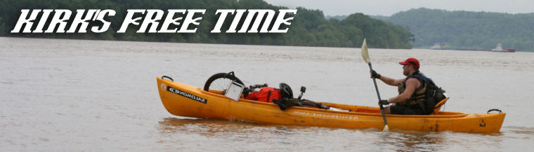
Here's a couple of extra pictures from the race:


Thursday, March 12, 2009
Eco Lonestar Extreme Adventure Race
Location: Sam Houston National Forest (North end of Lake Conroe)
Team Name: Light & Momentary Troubles (LMT)
Team Members: Kirk Zeringue, Damon Pourciau, Sara Welch
Temperature (start/high/finish): 68/81/74
Results: 17/18 Coed, 25/28 overall
Pre-Pre-Race
On Wednesday evening, I was walking from my house to start an 8 mile run. While walking (it always happens while walking, never while actually doing something athletic), I was making some adjustments to my iPod and I rolled my ankle. I know, some of you are saying “what else is new?!” Normally, I would agree with you, but this time the sprain was obviously worse than the ones I‘ve been getting monthly (at least it seems that frequent) for the last 6 years. It was pretty embarrassing because I stumbled to the ground in the middle of the road, jumped up and started my normal routine…step, skip, EXPLETIVE…step, skip, EXPLETIVE… Apparently the fall looked bad enough for 2 cars to stop and make sure I was OK. One offered me a ride home, which I declined since I was a mere 2 houses away from my house. I hobbled back home…immediately concerned over whether or not I could (should) do this race in 3 days.
Pre-Race
We left LaPlace at 9:15pm (yep, I decided to race, albeit with a fairly immobilizing brace on) on Friday which put us at the TA around 4:15am on Saturday morning. The race was to start at 7am. We took about an hour nap once we got there and the started setting up our TA. TA went up pretty quick and all 3 of us were able to attend the pre-Race meeting (that doesn’t always happen with LMT)! If you do the math, we were about to attempt this 12 hour race very sleep deprived (less than 2 hours in the previous 24), which was actually part of the plan. Damon wanted to see how he (we) would respond under those conditions since we plan on doing even longer races this year. There weren’t any real surprises in the pre-race meeting, just typical stuff except the passing mention of mountain biking in the sand. This immediately caught my attention, since my previous attempts at biking in the sand were less than stellar (stop laughing Lori and Paul!). We were also informed that one team member from each team would do a short sprint to retrieve the maps and first set of coordinates at the start of the race. We were also reminded that the race cut-off was at 7pm (with a 1 CP penalty for every 5 minutes you were late).
Leg 1 (Trek)
The race started around 7:15am (after the start of the 2 hour sprint race going on at the same time). We gathered at the start line where we noticed the overwhelming majority of teams had gaiters on over there lower legs. Apparently we didn’t get that memo (not that it really mattered because none of us own gaiters anyway). This was an obvious sign of things to come and that we would likely finish the race with cut up ankles and shins. Damon sprinted away to go fetch our maps. He returned about 2 minutes later barely able to breathe…I guess it made him feel good to be with the leaders at the beginning (that would be the last time all day). I was happy he got that sprinting out of his system because I knew our pace on foot the rest of the day would be pretty slow (due to my ankle). We plotted our first 2 CPs, grabbed our packs, and took (hobbled) off. We were allowed to get CPs 1 & 2 in any order…we opted to get CP1 first. We ran (I run-limped) about 3km down a couple of paved roads, turned off on a sandy trail, downhill to the creek where CP1 was located.
 We followed the creek downstream about a kilometer to the intersection of the creek and a trail where CP2 was located. We jumped in and out of the creek, depending on what obstacles were in our way. The first entry into the creek was hilarious. The bank was about 4 feet higher than the creek bed, Damon jumped (stumbled) down and ended up face first in the water. Sara and I had a far less amusing entry …although I did almost hurt myself from laughing at Damon so hard. Minutes later we were trekking through the creek and down goes Damon again…backside first this time! Sara had one minor slip along the way, but kept her footing…she did bang her shin pretty hard though. I, on the other hand, with the gimp ankle didn’t fall at all. Still laughing at Damon, we finally reached CP2. We then followed a trail most of the way back to the TA. This leg took was about 9 km long.
Leg 2 (Paddle - Trek - Paddle)
We plotted our coordinates for CPs 3 – 5, made some gear adjustments and were in and out of the TA in about 10 minutes. We headed to the boat staging area, picked up our canoe, and portaged it for about 1/4 of a mile to the water’s edge. We were instructed to get the CPs in order for this leg. The first 10 minutes of paddling was pleasant…think of a calm winding bayou. The next two hours of paddling was hell…think of paddling uphill in a pinball machine. We were paddling in Lake Conroe or as I musically dubbed it…”Stump City” (sung in the style of Tower of Power’s “Bump City” from their song “Down to the Nightclub”…listen here - around 0:35).
 There were visible and submerged stumps everywhere! Add to that the 20 – 25 mph headwind, and needless to say, it was a long paddle. It took us an hour to get to CP3, and another 20 minutes to get to CP 4. At CP 4 we were instructed to get out the canoe with our packs and were handed a “special test” titled “Memory navigation.” We were to navigate to 3 checkpoints…CP A, B, and C. At each location, there would be a map mounted on a stake showing our current location and the location of the next CP. We were to use the map to come up with a route and then navigate to the CP using our memory. We glanced at the map and darted off. A minute or so later, I asked Damon a few questions, to which he didn’t really no the answer, so we went back to study the map this time. The guy manning the map gave us a hint as to how he would do it, and we took off. Same routine, I asked questions…no answers…we ran back to the map. On the way back, I suggested we take notes this time…quick check of the rules to make sure there wasn’t one preventing taking notes…there wasn’t. As we arrived back at the map, someone (I think Sara) asked the guy if we were the first team to come back twice…he said Yep! But he also said we were the first team “smart enough to take notes!” We may have been in second to last place at this point, but we took great pride in being smarter than any other team in the field (if only momentarily). Twenty minutes after we started this debacle, we had made zero progress. We took off again, notes in hand, along Damon’s planned route. Fifteen minutes in, our route was no longer mirroring Damon’s notes, we weren’t sure that we were where we thought we’d be. A lot of “what do you think…are you sure…nope” conversing took place. We finally agreed that if we went due west to the top of the hill, we should run into an old logging road and the CP should be at the top of the hill on that road. We bushwhacked for about 500 meters and sure enough, there was the road…whew! Just prior to this, I couldn’t help but remember the last line of our instruction sheet … “If you are lost, head east and you will eventually get to the lake. Then jump in!” Admittedly, that option was starting to look good. We followed the road to the top and there it was, CPA…Yay!!! We studied the map to CP B, which was located in a creek bed. Our plan was to head on a bearing that would intersect a draw, follow the draw down to the intersection of the creek and turn left at the creek leading us to the CP. I convinced Damon that we should overshoot the bearing to make sure we end up on the side of the CP we intended…made sense at the time. One problem, we unknowingly missed the draw, so when we hit he creek bed, we thought it was the draw ….followed it down stream until we hit the creek. After we bushwhacked downstream for a few hundred meters, we realized the error of our (my) ways and figured out that we had been in the creek bed (not the draw) all along…sorry guys. We turned around, headed back upstream straight to CP B. We found CP C with no trouble and headed back toward our boat. After 2 hours of traipsing around in the woods, we finally made it back to the boat…punched CP 4, and started the paddle back. I guesstimated we had about a 45 minute paddle remaining (turned out to be 55 minutes).
 The winds shifted a little causing a crosswind skewed to our boat. Paddling in our intended direction resulted in a feeling like we could tip the boat at any moment and it just seemed like we were going nowhere fast. We decided to paddle perpendicular to our intended direction in order to get the wind in our favor. We fought the wind for about 10 minutes and then made the turn…worked like a charm. It was great having that strong wind at our backs until we re-enter Stump City. Before we knew it, we found ourselves on top of a stump…we fought to break free, but to no avail. We were stuck! We tried everything we could think of (short of jumping out of the boat). Eventually, the wind swung us around and somehow we broke free. (I was on the verge of suggesting we vote who has to get out of the boat to set us free… of course I had an argument prepared why Damon should be the one…he was already soaked from falling in the creek twice…fortunately for Damon, it didn’t come to that because I know Sara would have sided with me) More stump dodging followed and we finally made it back to shore. Our reward…we had to portage the boats back to the TA. This time the portage involved a few breaks because our arms were whipped. We ended up paddling about 12km and portaging about 1km. Back at the TA, we received our next set of coordinates which was to be a bike leg.
Leg 3 (Bike)
We took our time in this TA…plotted CPs 6 – 13…traced our route…re-fueled…ate…40 minutes later we headed off on our bikes. I know I said earlier that we would never see the leaders again…I was wrong….we saw them heading out on their final trek leg while we were just leaving on the bike leg…Ouch! I estimated the bike leg to be about 34km which didn’t seem too bad at the time…little did we know that most of it would be on sandy trails. The first 3km was on paved roads…followed a sandy trail down to the creek for about 2km to retrieve CP6. We followed a series of sandy trails to CP7. It was pretty slow going between CP 6 and 7. It took us about an hour to go 7km. It was 4:30pm leaving us 2 and half hours before the race cutoff at 7pm. CP 8 was located at the farthest point from the TA so we decided to skip it to ensure we make it back before the cutoff (saved us about 8km of what we thought at the time would have been sandy trail riding…studying the maps a couple days later revealed that our sleep deprivation must have been affecting us because we chose routes through trails when roads were available…once again, ouch!) CP 9 was located under the middle of a road in a culvert barely large enough to crawl in (wish I had a picture of this)…thanks for getting that one Damon! Fast forward through more dreadful sandy trail riding and we punched CPs 10 and 11. At CP 11, we decided there probably wasn’t enough time left for us to get CPs 12 and 13 (even though they were pretty close by) so headed back to the TA which was about 6km away and paved the whole way (that was nice). Some of you may be wondering if you’ve ever read a race report from me that didn’t involve me cramping…well I’d hate to let you down. Eleven and a half hours into the race, on one of the last climbs, 1 mile from the end, both thighs knotted up bringing my ride to a halt. Damon and Sara patiently waited for me to overcome the pain (thanks) and I gingerly pedaled the last few minutes back to the TA where we punched CPs 14 & 15 and crossed the finish line with about 15 minutes to spare…granted there was still another trekking leg that we had no interest in attempting because of the penalty associated with missing the cut-off (1 CP per 5 minutes). We ended up covering about 29km and we all took some nice spills in the sand.
Leg 4 (Trek)
Did not attempt...this would have been the final trek leg.
All in all, I had a great time (I think we all did). My ankle held up pretty well. Sure, we came nowhere near clearing the course, but it was definitely great training for the next race. I learned a lot in this race and can’t wait for the next one (12 hour Natchez Trace Adventure Race in Tennessee, March 21!).
Tuesday, March 3, 2009
Caribbean Cruise over Mardi Gras
Lori and I went on a “7 night Exotic Western Caribbean Cruise” the week of Mardi Gras. Scarlett, Damon, Stella, Jamie, Caroline, and Damon’s parents/grandmother/aunt were also on the trip.
The boat set sail around 6pm on the Sunday before Mardi Gras from New Orleans. We had lunch at Frenier Landing (highly recommend) with my parents who then dropped us off at the terminal. Traffic getting through New Orleans (parades) made for a little longer drive than usual, but we made it in plenty of time. The Pourciau’s, on the other hand, had a far more eventful ride in…hopefully Scarlett will include all those details in Stella’s blog!
The itinerary had us Sunday night and Monday at sea, Tuesday in Costa Maya, Wednesday in Guatemala, Thursday in Belize, Friday in Cozumel/Playa Del Carmen, Saturday at sea, and back in NOLA first thing Sunday morning.
The days at sea consisted of eating, shows, working out (mostly Lori), ping pong, eating, napping, eating, etc.
In Costa Maya, we (me, Lori, Damon and his dad) bike and kayak shore excursion….I will provide details when Damon gets his pictures developed since Lori and I didn’t take any. I think we all had a great time! Here's a couple from the ship:


In Guatemala, we (Zeringues, 5/7 of the Pourciaus, Jamie, and Caroline) spent the day relaxing, playing beach volleyball and ping pong, and eating at the Amatique Bay Resort. Once again, no pictures yet from the excursion, but here’s a couple from the ship:

 In Belize, we (Zeringues, 2/7 of the Pourciaus, Jamie, and Caroline) took about an hour ride into the jungle to go aerial trekking (ziplines) and cave tubing …this was definitely the highlight of the shore excursions. Once again, no pictures yet.
In Cozumel/Playa del Carmen, we (Zeringues, 1/7 of the Pourciaus - Scarlett, Jamie, and Caroline) took a nauseating 45 minute boat ride to the mainland, followed by a 1 hour bus ride to the Tulum Mayan ruins. I have a ton of pictures there…here’s a sampling.
Not yet nauseated!


 These iguanas were everywhere!
 This picture is totally staged!
  "Should we go in?"
 "Yep!"

 I was impressed with this wall. It surrounded the entire site and was about 10 - 15 feet wide and 10 - 15 feet tall.
Here's some signs in Cozumel that Lori found entertaining:


In short, we all had a great time. The seas were a little rougher than my previous cruises, but not too bad. (Lori tends to get motion sickness, but handled the conditions pretty well) The onship entertainment was average…some good, some bad. The food was average…some good, some bad (didn’t stop us from eating way too much of it -especially the men). The ship was spotless. The rooms were small (duh…it’s a cruise ship). I’d say 3/4 of our excursions were great! I'll update the pictures as I get them!
Subscribe to:
Posts (Atom)